Le Rochail (3022 m a.s.l., Écrins)
Register and log summit


About peak Le Rochail
 Francie
Vrchol Le Rochail was added here by Milan "Hojší" Průžek and info was completed by Martin Matějka a Jan Blažej.
Le Rochail is a peak located in the French department of Isère, in the Écrins massif. It was the first "3" of the massif coming from Grenoble, when its snow-capped summits emerged from the Bourg-d'Oisans plateau, and the westernmost of all the Alps.
It is one of the few that can be climbed without basic mountaineering, either from Villard-Notre-Dame or Chantelouve, and in both cases via the Col du Rochail.
Rochail is an orographic knot from which three ridges emerge. The northeast ridge leads to Héritiere (2,906 m) and further to Aiguille du Midi (2,742 m). It continues descending towards the southwest tip of the Bourg d'Oisans plateau. This ridge is the beginning of a massive horseshoe that surrounds the Vénéon valley and includes almost all the highest peaks of Écrins. The northwest ridge leads to the summit of Col d'Ornon (2,872 m), Grand Renaud (2,776 m), and Petit Renaud (2,606 m). The southern ridge leads to Pointe de Malhaubert (3,049 m), the highest point of the range, and Pointe de Confolens (2,990 m).
- Chalet/accommodation
-
There is no chalet on the peak.
- Stroller access
-
Peak is not stroller accessible.
- Views
-
There are views from the peak.
- Cable car
-
There is no cable car to this peak.
- Equipment
-
No special equipment is required for this summit.
- Accessibility
-
Peak is freely accessible.
Nearest peaks: Pointe de Malhaubert (3049 m, 0.5 km)
Routes nearby
Routes provided by SvetOutdooru.cz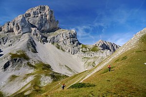
Webcams
(2064 m a.s.l., 6.7 km)
 Les Deux Alpes
(519 m a.s.l., 6.7 km)
 Les Deux Alpes: Les 2 Alpes, Vallée Blanche à 2100m
(2067 m a.s.l., 7.1 km)
 Les Deux Alpes: Les 2 Alpes
( 7.7 km)
 Le Bourg-d'Oisans › North-East
(522 m a.s.l., 8 km)
 Les Deux Alpes: Les 2 Alpes - Clos des Fonds
( 8.6 km)
 Les Deux Alpes › East: La Grande Aiguille
( 8.7 km)
 Les Deux Alpes: Clos des Fonds
( 8.7 km)
Sun
| today | tomorrow | day after tomorrow | |
|---|---|---|---|
| Dawn: | 6:37 | 6:38 | 6:39 |
| Sunrise: | 7:07 | 7:08 | 7:10 |
| Sunset: | 17:31 | 17:30 | 17:28 |
| Dusk: | 18:02 | 18:00 | 17:59 |