

Hiking, 23 km
13.9.2026
 Česko
Jeseník (Olomoucký kraj)
Logged on Vrcholovka 34x in total. Peak information here was completed by Bouřka, Martin Matějka a Jiří Králík.
Ztracený vrch is part of challenges: Koruna Sudet, Menagerie, Nejhory Olomoucka, Thousanders of the Czech Republic, Thousanders of the Jeseníky
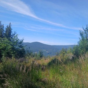
An elongated hill 5 km northwest of Videl, on the western ridge of Jelení loučky, separated by a saddle at an elevation of 1056 m above sea level. Covered with mixed and spruce forests. The summit is marked by a pile of stones 5 m southwest of the unmarked trail. No views. (tisicovky.cz)
There is no chalet on the peak.
Peak is not stroller accessible.
There are no views from the peak.
There is no cable car to this peak.
No special equipment is required for this summit.
Peak is freely accessible.
Nearest peaks: Kamzičí skála (989 m, 0.5 km) Zaječí hora (1012 m, 1 km) Lysý vrch (1128 m, 1.2 km) Jelení loučky (1205 m, 1.7 km) Bělská stráň (822 m, 2.2 km) Hnědý vrch / Malé Bradlo (1044 m, 2.4 km) Sýkorka (720 m, 2.7 km) Ostruha (1023 m, 2.8 km) Ostruha JV (1022 m, 2.8 km) Javorový vrch (1078 m, 2.9 km) Krkavčí vrch (720 m, 3.1 km) Velké Bradlo Z (1041 m, 3.5 km) Mrazový vrch (980 m, 3.7 km)
 Bela pod Pradedem: Červenohorské sedlo
 Bela pod Pradedem: Červenohorské sedlo
 Bela pod Pradedem: Červenohorské sedlo
 Kouty nad Desnou: Červenohorské sedlo - Modrá sjezdovka - dojezd k lanové dráze
 Loucna nad Desnou
 Rejhotice: Sporthotel Kurzovní - Vysoké hole
 Rejhotice: Sporthotel Kurzovní - Přístup na běžeckou trať
 Rejhotice: Sporthotel Kurzovní - Parkoviště a hlavní vchod
 Rejhotice: Sporthotel Kurzovní - Petrovy kameny
 Karlova Studánka: Sporthotel Kurznovní
 Mala Moravka: Praděd - Horský hotel Volareza - Horská služba
 Mala Moravka: Praděd - Horský hotel Volareza
 Mala Moravka: Praděd - Horský hotel Volareza - Bílá Opava
 Mala Moravka: Praděd - Horský hotel Volareza - Petrovy kameny
 Dolni Lipova: Skiareál - Skipark Filipovice - Horní stanice Lanové dráhy
 Karlova Studanka: Lyžařský vlek - Sjezdovka
 Jesenik

| today | tomorrow | day after tomorrow | |
|---|---|---|---|
| Dawn: | 5:57 | 5:59 | 6:00 |
| Sunrise: | 6:31 | 6:32 | 6:34 |
| Sunset: | 16:38 | 16:37 | 16:35 |
| Dusk: | 17:12 | 17:10 | 17:08 |