




Hiking
st, 31.12.2025, 15:21
 Maďarsko
Logged on Vrcholovka 4x in total. Vrchol Galya-tető was added here by Martin Matějka and info was completed by Jiří Králík.
Galya-tető is part of challenge: TOP 10 Hungary
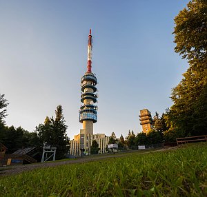
The second highest mountain in Hungary. There is a lookout tower on the eastern peak. The summit is freely accessible and marked by a concrete milestone. In the immediate vicinity, there is a transmitter and an old dilapidated cabin area. The best way to reach the summit is around the fence from the north and west sides. Overgrown with no views.
There is a chalet on the peak.
Peak is not stroller accessible.
There are no views from the peak.
There is no cable car to this peak.
No special equipment is required for this summit.
The summit is outside the fenced area and is accessible.
Nearest peaks: Péter hegyese (960 m, 0.5 km) Lengyendi-galya (937 m, 0.9 km) Nyesett-vár (813 m, 1.5 km) Piszkés-tető (952 m, 1.5 km) Kis Piszkés-tető (949 m, 1.7 km) Mogyorós-orom (848 m, 1.7 km) Üvöltő-hegy (732 m, 1.8 km) Nyírjes-bérc (753 m, 1.9 km) Csonka-bérc (735 m, 2.3 km) Haranglába-tölgyes (610 m, 2.4 km) Csomoszvár (561 m, 2.5 km) Kis-Galya (778 m, 2.6 km) Lajszka (558 m, 3.4 km) Pálinkázó (726 m, 3.4 km) Hajnács-hegy (569 m, 3.6 km)
| today | tomorrow | day after tomorrow | |
|---|---|---|---|
| Dawn: | 5:42 | 5:44 | 5:45 |
| Sunrise: | 6:14 | 6:15 | 6:17 |
| Sunset: | 16:34 | 16:32 | 16:31 |
| Dusk: | 17:06 | 17:04 | 17:02 |





