

Hiking, 41 km
22.2.2020
Česko
Klatovy (Plzeňský kraj)
Logged on Vrcholovka 5x in total. Vrchol Nad Tmavým potokem was added here by Bouřka and info was completed by Vladimír Grančay, Krtek a Martin Matějka.
A peak in a restricted zone, relatively accessible from the asphalt road, which is also forbidden... :-)
Height on the ČÚZK map is 1076.8 m and the saddle below the contour line is 1071 m, giving a prominence of 6 m and an unofficial secondary thousand-meter peak.
There is no chalet on the peak.
Peak is not stroller accessible.
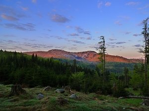
There are views from the peak.
There is no cable car to this peak.
No special equipment is required for this summit.
Peak is freely accessible.
Nearest peaks: Oblík (1228 m, 1 km) Oblík SZ (1167 m, 1.4 km) Oblík S (1128 m, 2 km) Smrkový vrch (1111 m, 2 km) Smrkový vrch V (1089 m, 2.1 km) Předěl (1242 m, 2.3 km) Jezernice JZ (1248 m, 2.4 km) Jezernice (1266 m, 2.6 km) Nad Latschensee (1163 m, 3.2 km) Nad Latschensee JV (1117 m, 3.2 km) U Schwartzova statku (956 m, 3.2 km) Přední Mlynářská slať (1063 m, 3.3 km) Pamferfleck V (1165 m, 3.4 km)
 Kaltenbrunn: Poledník, pohled na jih
 Kaltenbrunn: Poledník
 Srni: Srní - Staré Srní, Šumava - Böhmerwald
 Srní: pohled ke Starému
 Prášily

| today | tomorrow | day after tomorrow | |
|---|---|---|---|
| Dawn: | 6:31 | 6:32 | 6:33 |
| Sunrise: | 7:04 | 7:06 | 7:08 |
| Sunset: | 16:35 | 16:33 | 16:32 |
| Dusk: | 17:09 | 17:07 | 17:06 |