Hiking, 46 km
4.10.2026
 Česko
Česká Lípa (Liberecký kraj)
Logged on Vrcholovka 48x in total. Vrchol Stožec V was added here by Bouřka.
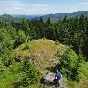
A very nice mound near the green hiking trail. Partially forested with beech trees, but in the leafless season, there is surprisingly good visibility from the summit. Height according to ags.cuzk.cz is 662.2m.
There is no chalet on the peak.
Peak is not stroller accessible.
There are views from the peak.
There is no cable car to this peak.
No special equipment is required for this summit.
Peak is freely accessible.
Nearest peaks: Stožec (665 m, 0.3 km) Jelení kámen (663 m, 0.4 km) Konopáč V (662 m, 0.6 km) Velký Šébr (633 m, 0.7 km) Konopáč (676 m, 0.8 km) Pětikostelní kámen (690 m, 1 km) Pěnkavčí vrch J (740 m, 1.4 km) Bouřný (703 m, 1.5 km) Bučina (537 m, 1.6 km) Pěnkavčí vrch (792 m, 1.8 km) Kobyla S (596 m, 2.2 km) Tři bratři (533 m, 2.2 km) Tolštejn (670 m, 2.3 km) Velký Buk (736 m, 2.4 km) Kozí hřbet (593 m, 2.6 km) Kobyla (625 m, 2.7 km) Bouček (662 m, 2.8 km) Zaječí vrch (631 m, 3 km) Ptačinec (679 m, 3.1 km) Pařez (532 m, 3.4 km) Rohál (652 m, 3.4 km) Malý Buk SV3 (617 m, 3.6 km) Weberberg (710 m, 3.6 km) Malý Buk SV2 (615 m, 3.7 km)
 Túra za zkamenělými jeptiškami a historickými lomy do Žitavských hor
 Grossschonau › North-west: Lausche / Luž Observation Tower - Lusatian Mountains
 Horni Podluzi › South
 Grossschonau › South
 Grossschonau
 Polevsko
 Polevsko
 Polevsko

| today | tomorrow | day after tomorrow | |
|---|---|---|---|
| Dawn: | 7:06 | 6:07 | 6:09 |
| Sunrise: | 7:39 | 6:41 | 6:43 |
| Sunset: | 17:51 | 16:49 | 16:48 |
| Dusk: | 18:25 | 17:23 | 17:21 |