Cordillera Occidental (Ekvádor)

Export peaks

Export generates a GPX file with peaks that can be uploaded to GPS navigation or phone app.

Plan route

Click a peak or chalet and then "Add to planning" to add route points. You can also add points by right-clicking on the map.
After page reload, route planning is lost.

    Chalets

    Filters only chalets where this feature is filled in.

    By summit history

    Legend

    Green points are visited peaks, red points are not visited.
    PeakPeaks with prominence 15 m and more
    Secondary peakPeaks with prominence 5-15 m
    Point of interestSignificant point with minimum prominence created for challenge purposes
    Rest pointElevation point with prominence below 5 m
    UnclassifiedPeaks waiting for classification
    ChaletMountain chalet

    Challenges

    Peaks


    Filters only peaks where this feature is filled in.
    m
    m
    m
    m
    m
    m
    Not all peaks have listed isolation.
    Highest peak Chimborazo (6263 m a.s.l.)
    Most prominent peak Chimborazo (6263 m a.s.l., prominence 4122 m)
    Parent unit Northern Andes
    Main peaks Total 30
    Most popular peaks Monte Juyende (3930 m a.s.l.), Rucu Pichincha (4696 m a.s.l.), Cruz Loma SZ (4000 m a.s.l.), Panecillo (3016 m a.s.l.), Quilotoa (3909 m a.s.l.)
    Name Elevation
    Chimborazo Chimborazo 6263 m a.s.l.
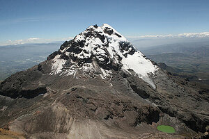
    Iliniza Sur Iliniza Sur 5248 m a.s.l.
    Illiniza Norte Illiniza Norte 5126 m a.s.l.
    Carihuairazo Carihuairazo 5018 m a.s.l.
    Cotacachi Cotacachi 4944 m a.s.l.
    Corazón Corazón 4790 m a.s.l.
    Guagua Pichincha Guagua Pichincha 4776 m a.s.l.
    Rucu Pichincha Rucu Pichincha 4696 m a.s.l.
    Padre Encantado Padre Encantado 4600 m a.s.l.
    Ladrillos Ladrillos 4577 m a.s.l.
    Ñaupán Ñaupán 4514 m a.s.l.
    Atacazo Atacazo 4463 m a.s.l.
    Cerro Chorrera Cerro Chorrera 4445 m a.s.l.
    Cerro Paraguillas Cerro Paraguillas 4419 m a.s.l.
    Cerro San Luis Cerro San Luis 4295 m a.s.l.
    Cerro Tiopungu Cerro Tiopungu 4175 m a.s.l.
    San Francisco El Picatcho San Francisco El Picatcho 4085 m a.s.l.
    Cruz Loma SZ Cruz Loma SZ 4000 m a.s.l.
    Cerro Puñalica Cerro Puñalica 3988 m a.s.l.
    Monte Juyende Monte Juyende 3930 m a.s.l.
    Quilotoa Quilotoa 3909 m a.s.l.
    Cerro Cruzurco Cerro Cruzurco 3892 m a.s.l.
    Loma Saquigua Loma Saquigua 3839 m a.s.l.
    Monte Juyende S1 Monte Juyende S1 3810 m a.s.l.
    Monte Juyende S2 (Cola) Monte Juyende S2 (Cola) 3780 m a.s.l.
    Cerro Ungüí Cerro Ungüí 3578 m a.s.l.
    Casitagua Casitagua 3499 m a.s.l.
    Sincholagua Sincholagua 3356 m a.s.l.
    Cojitambo Cojitambo 3020 m a.s.l.
    Panecillo Panecillo 3016 m a.s.l.
    Cerro Pondoña Cerro Pondoña 2984 m a.s.l.
    Share