
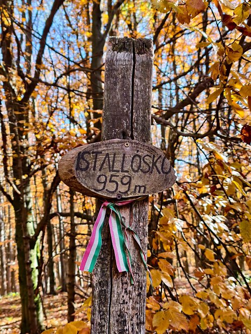



Cycling, 52 km
12.8.2020
 Maďarsko
Logged on Vrcholovka 4x in total. Vrchol Istállós-kő was added here by Martin Horáček and info was completed by Jiří Králík.
Not long ago, Istállós-kő was considered the highest peak in the Bükk Mountains.
Interestingly, on a map from 1995 published by the Ministry of Agriculture, Kettős-bércet was already marked as higher. On the map, Istállós-kő is 958.1 meters high, the northern peak of Kettős-rent is 958.2 meters, and the southern peak of Kettős-rent is 961.0 meters. József Regős began to investigate this map.
Since then, more measurements have been taken at the peaks, for example, in 2000 they tested an optical leveling instrument, but they worked under quite harsh conditions. It then turned out that Kettős-bércet is 1.8 meters higher. Another measurement was attempted by György Salétli, a nature conservation guardian, but that was not conclusive either.
The latest measurement was conducted on January 8, 2014, by employees of Földméter Kft. - Gábor Haffner and Ádám Kesztler - using a Nomad Spectra Precision GPS with an accuracy of 0.05 m. The measurement lasted more than half an hour, and the displayed height was 960.715 meters. This proved that the highest point of the Bükk is the southern peak of Kettős-mercc. Scientists also proposed a new name for this peak, which is Szilvási-kő.
There is no chalet on the peak.
Only suitable for off-road driving.
There are no views from the peak.
There is no cable car to this peak.
No special equipment is required for this summit.
Peak is freely accessible.
Nearest peaks: Szilvási-kő (961 m, 0.4 km) Kettős-bérc S (959 m, 0.5 km) Kis-hegy (935 m, 0.5 km) Ispán-hegy (912 m, 0.8 km) Nagy-Kopasz (907 m, 0.8 km) Virágos-sár-hegy (955 m, 1.1 km) Felső-Nagy-verő (728 m, 1.3 km) Kőris-hegy (945 m, 1.3 km) Kukucsó-hegy (938 m, 1.3 km) Kálmán-hegy (875 m, 1.4 km) Küllő-hegy (902 m, 1.4 km) Vörös-sár-hegy (951 m, 1.4 km) Alsó-Nagy-verő (706 m, 1.6 km) Kőrös-bérc (956 m, 1.6 km) Sima-hegy (876 m, 1.7 km) Kerek-rét-fő (882 m, 1.9 km) Kis-tanya (916 m, 1.9 km) Almád-hegy (861 m, 2.2 km) Pes-kő (865 m, 2.2 km) Csortos-kő (633 m, 2.3 km) Fekete-Sár-bérc (937 m, 2.3 km) Büszkés-hegy (954 m, 2.4 km) Huta-bérc (923 m, 2.4 km) Leány-hegy (893 m, 2.4 km) Őr-kő (885 m, 2.6 km) Hegyes-kő (857 m, 2.7 km) Ölyves-völgyfő (934 m, 2.9 km) Kecskor-hegyese (692 m, 3.3 km)
| today | tomorrow | day after tomorrow | |
|---|---|---|---|
| Dawn: | 5:48 | 5:49 | 5:50 |
| Sunrise: | 6:20 | 6:21 | 6:23 |
| Sunset: | 16:23 | 16:21 | 16:20 |
| Dusk: | 16:55 | 16:54 | 16:52 |




