Cycling, 70 km
14.9.2025
 Česko
Chomutov (Ústecký kraj)
Logged on Vrcholovka 17x in total. Vrchol Eduardova skála was added here by Michaela and info was completed by Nojby.
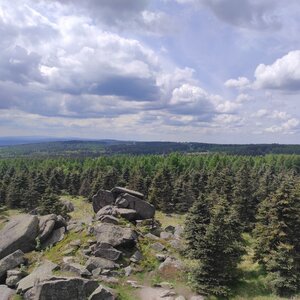
The lookout rock on the edge of the forest above Malý Háj forms the western forepeak of Lesenská planina. The rock massif, visible from afar, is located approximately 0.8 km southeast of the Malý Háj church, east of the Malý Háj - Lesná road. At the summit of the rocky mound stands the historic pillar of the Royal Saxon triangulation - Station 83 Grossenstein (rock prism, 909.9 m). The prism is about 1 m high, making the highest point of the rock 909 m.
From the top, there is a relatively distant view, especially to the west. To the southeast, Medvědí skála, Lesenská planina, Liščí vrch; to the north, Hora Svaté Kateřiny; to the west, the settlements of Malý Háj and Rudolice in the Mountains are clearly visible, further away Kamenný vrch, the valley of the Telčský potok, and the more distant peaks of the Krušné hory; to the south, the settlement of Lesná.
There is no chalet on the peak.
Peak is not stroller accessible.
There are views from the peak.
There is no cable car to this peak.
No special equipment is required for this summit.
Peak is freely accessible.
Nearest peaks: Lesenská pláň (921 m, 0.6 km) Lesná (912 m, 1.4 km) Malohájský vrch (842 m, 1.9 km) Růžový vrch (732 m, 2.6 km) Vraní vrch (686 m, 3.4 km)
 Hora Svaté Kateřiny
 Vysoka Pec › West
 Vysoka Pec: Ski resort Proud
 Vysoka Pec › West: Ski resort Proud
 Deutschneudorf › West: Oberlochmühle - Erzgebirgsidyll am Glockenwanderweg - Kapelle am Weg

| today | tomorrow | day after tomorrow | |
|---|---|---|---|
| Dawn: | 6:18 | 6:19 | 6:21 |
| Sunrise: | 6:52 | 6:54 | 6:55 |
| Sunset: | 16:47 | 16:45 | 16:44 |
| Dusk: | 17:21 | 17:19 | 17:18 |